Coming soon: Create your own topo maps!

TopoCreator

Customizable high-quality topographic maps

Home » State maps and elevation data

Terms of use. All maps displayed on this page or downloadable via a "download" link on this page are © 2009 topocreator.com released to the public under a Creative Commons Attribution-Share Alike license. Maps are available for purchase for a small fee for educational, personal, and commercial usage under an alternative license. The elevation data used in the creation of these maps has been obtained through the USGS, NOAA, and the US Census Bureau via the public domain.


Alaska (AK)

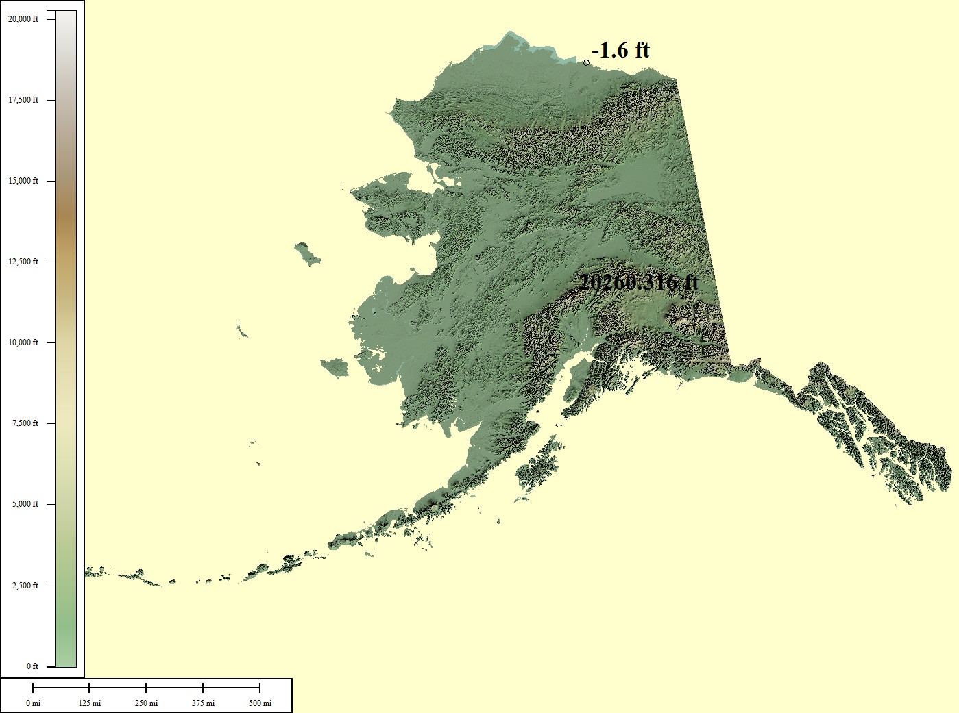
2,833,084 sq mi
Mt McKinley - 20,320ft, Artic Ocean - 0ft
Creative Commons License
Green/Brown Shading with High/Low Points
Lowest points may include strip mines significantly lower than surrounding area
Medium resolution JPG 1399x1041:
Preview | Download FREE
High resolution JPG 1834x1349:
Watermarked Preview | Add to Cart $0.99
Ultra resolution JPG 4445x3196:
Watermarked Preview | Add to Cart $1.99
Download the National Elevation Dataset

Select one of the options below if you would like to download the elevation data used to create this map.

60m GMG (910.5 MB) Preview | Add to cart $24.99
View Cart | Checkout

Select another state or map style
Alabama (AL)

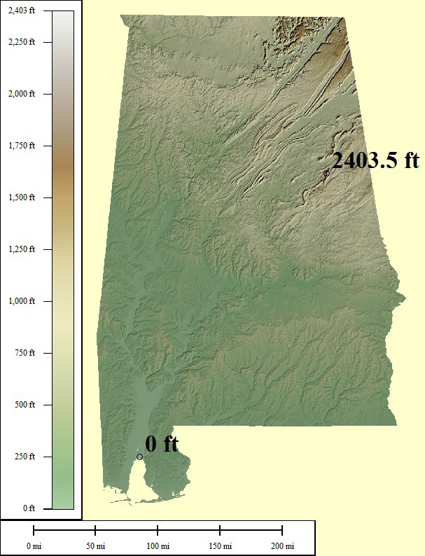
75,032 sq mi
Mt Cheaha - 2,407ft, Gulf of Mexico - 0ft
Creative Commons License
Green/Brown Shading with High/Low Points
Lowest points may include strip mines significantly lower than surrounding area
Medium resolution JPG 607x794:
Preview | Download FREE
High resolution JPG 1690x2451:
Watermarked Preview | Add to Cart $0.99
Ultra resolution JPG 3887x6002:
Watermarked Preview | Add to Cart $1.99
Download the National Elevation Dataset

Select one of the options below if you would like to download the elevation data used to create this map.

30m GMG (254.1 MB) Preview | Add to cart $19.99
View Cart | Checkout

Select another state or map style
Arkansas (AR)

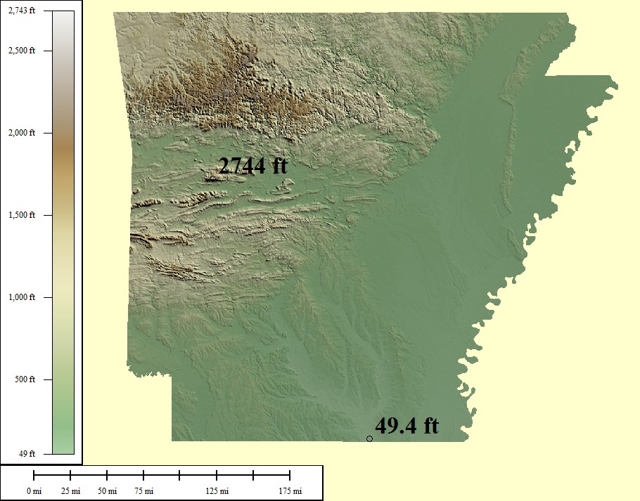
69,493 sq mi
Mt Magazine - 2,753ft, Ouachita River - 50ft
Creative Commons License
Green/Brown Shading with High/Low Points
Lowest points may include strip mines significantly lower than surrounding area
Medium resolution JPG 910x713:
Preview | Download FREE
High resolution JPG 2556x2138:
Watermarked Preview | Add to Cart $0.99
Ultra resolution JPG 6167x5191:
Watermarked Preview | Add to Cart $1.99
Download the National Elevation Dataset

Select one of the options below if you would like to download the elevation data used to create this map.

30m GMG (124.2 MB) Preview | Add to cart $14.99
View Cart | Checkout

Select another state or map style
Arizona (AZ)

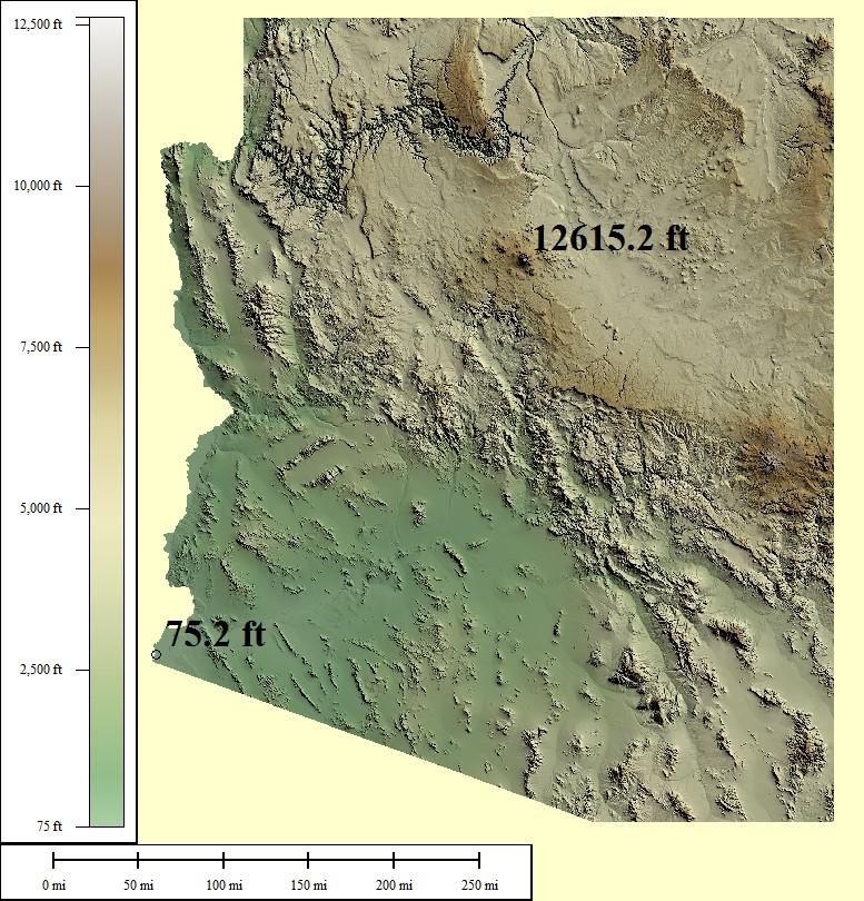
133,291 sq mi
Humphreys Peak - 12,637ft, Colorado River - 70ft
Creative Commons License
Green/Brown Shading with High/Low Points
Lowest points may include strip mines significantly lower than surrounding area
Medium resolution JPG 777x810:
Preview | Download FREE
High resolution JPG 2204x2499:
Watermarked Preview | Add to Cart $0.99
Ultra resolution JPG 5262x6117:
Watermarked Preview | Add to Cart $1.99
Download the National Elevation Dataset

Select one of the options below if you would like to download the elevation data used to create this map.

30m GMG (573.1 MB) Preview | Add to cart $19.99
View Cart | Checkout

Select another state or map style
California (CA)

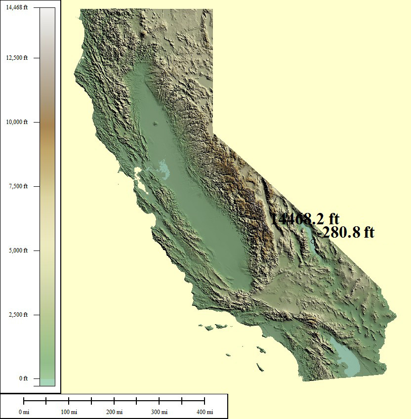
393,043 sq mi
Mt Whitney - 14,505ft, Death Valley - (-282ft)
Creative Commons License
Green/Brown Shading with High/Low Points
Lowest points may include strip mines significantly lower than surrounding area
Medium resolution JPG 832x848:
Preview | Download FREE
High resolution JPG 2360x2608:
Watermarked Preview | Add to Cart $0.99
Ultra resolution JPG 5635x6378:
Watermarked Preview | Add to Cart $1.99
Download the National Elevation Dataset

Select one of the options below if you would like to download the elevation data used to create this map.

30m GMG (812.8 MB) Preview | Add to cart $24.99
View Cart | Checkout

Select another state or map style
Colorado (CO)

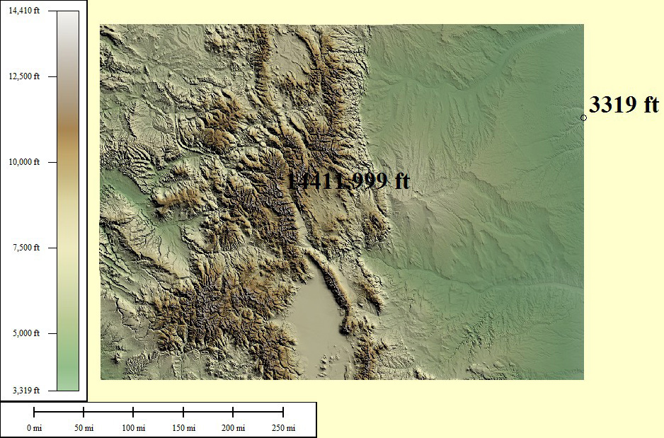
118,740 sq mi
Mt Elbert - 14,440ft, Arikaree River - 3,315ft
Creative Commons License
Green/Brown Shading with High/Low Points
Lowest points may include strip mines significantly lower than surrounding area
Medium resolution JPG 938x619:
Preview | Download FREE
High resolution JPG 2664x1798:
Watermarked Preview | Add to Cart $0.99
Ultra resolution JPG 6075x4325:
Watermarked Preview | Add to Cart $1.99
Download the National Elevation Dataset

Select one of the options below if you would like to download the elevation data used to create this map.

30m GMG (294.4 MB) Preview | Add to cart $19.99
View Cart | Checkout

Select another state or map style
Connecticut (CT)

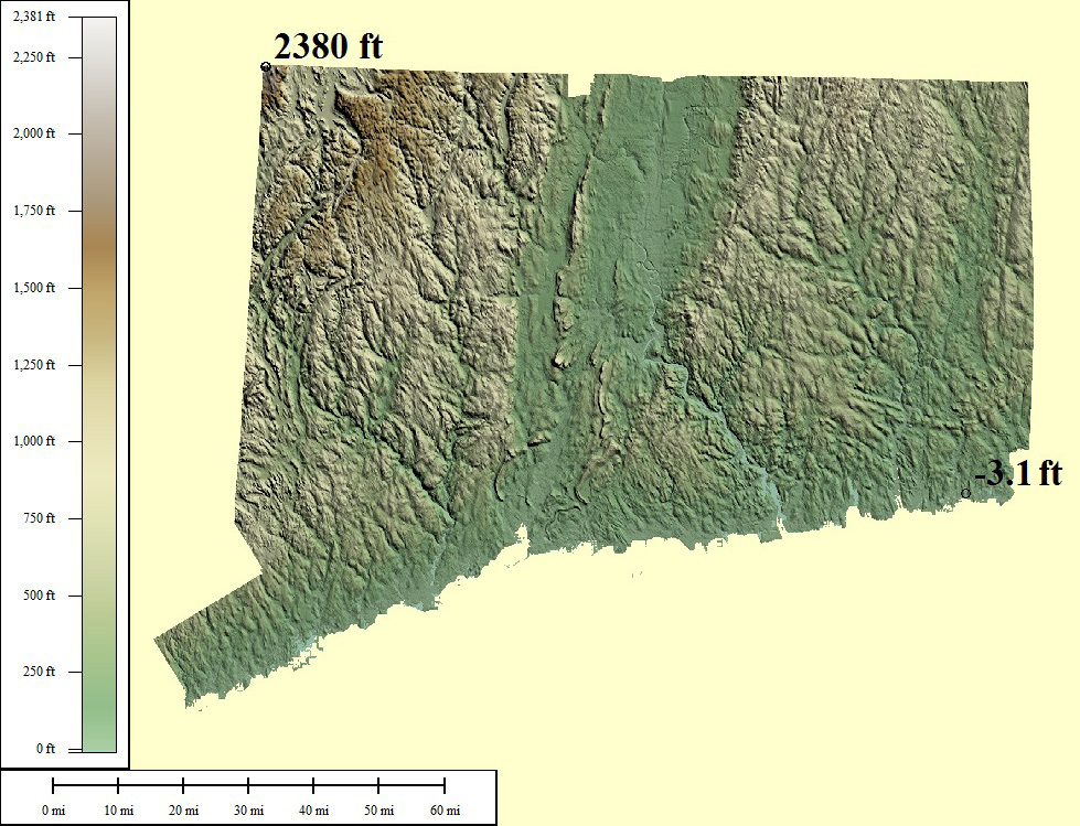
7,969 sq mi
Mt Frissell - 2,380ft, Long Island Sound - 0ft
Creative Commons License
Green/Brown Shading with High/Low Points
Lowest points may include strip mines significantly lower than surrounding area
Medium resolution JPG 979x749:
Preview | Download FREE
High resolution JPG 2841x2201:
Watermarked Preview | Add to Cart $0.99
Ultra resolution JPG 6848x5314:
Watermarked Preview | Add to Cart $1.99
Download the National Elevation Dataset

Select one of the options below if you would like to download the elevation data used to create this map.

30m GMG (14.5 MB) Preview | Add to cart $9.99
View Cart | Checkout

Select another state or map style
District of Columbia (DC)

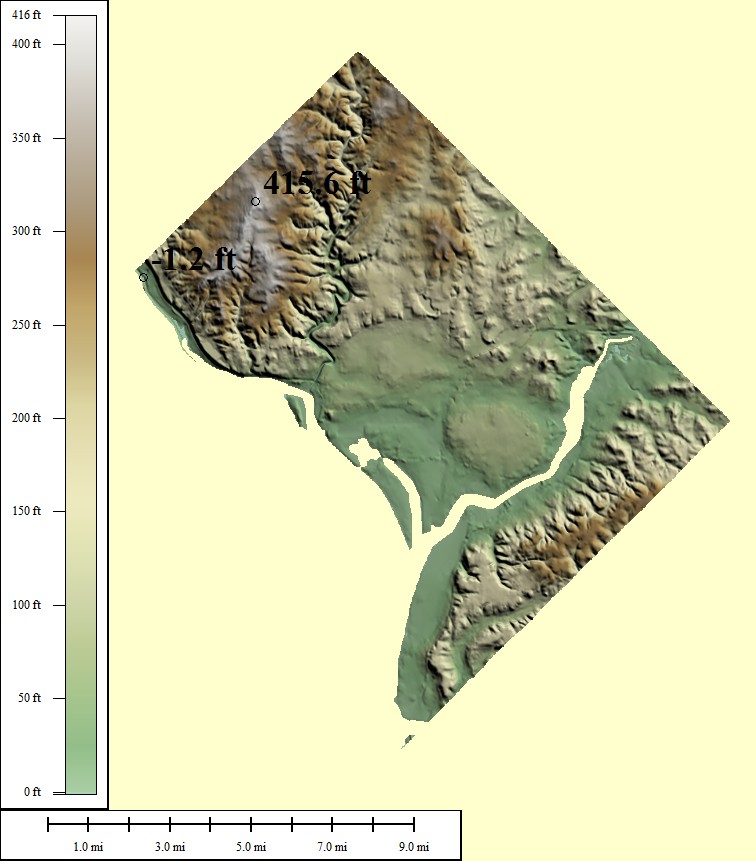
167 sq mi
Fort Reno - 410ft, Potomac River - 1ft
Creative Commons License
Green/Brown Shading with High/Low Points
Lowest points may include strip mines significantly lower than surrounding area
Medium resolution JPG 756x861:
Preview | Download FREE
High resolution JPG 2140x2656:
Watermarked Preview | Add to Cart $0.99
Ultra resolution JPG 5106x6502:
Watermarked Preview | Add to Cart $1.99
Download the National Elevation Dataset

Select one of the options below if you would like to download the elevation data used to create this map.

30m GMG (209.5 KB) Preview | Add to cart $4.99
View Cart | Checkout

Select another state or map style
Delaware (DE)

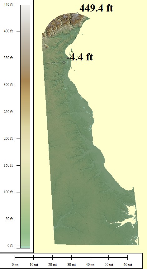
5,045 sq mi
Ebright Azimuth - 451ft, Atlantic Ocean - 0ft
Creative Commons License
Green/Brown Shading with High/Low Points
Lowest points may include strip mines significantly lower than surrounding area
Medium resolution JPG 472x864:
Preview | Download FREE
High resolution JPG 1215x2666:
Watermarked Preview | Add to Cart $0.99
Ultra resolution JPG 2773x6527:
Watermarked Preview | Add to Cart $1.99
Download the National Elevation Dataset

Select one of the options below if you would like to download the elevation data used to create this map.

30m GMG (3.8 MB) Preview | Add to cart $9.99
View Cart | Checkout

Select another state or map style
Florida (FL)

221,869 sq mi
Britton Hill - 345ft, Atlantic Ocean - 0ft
Creative Commons License
Green/Brown Shading with High/Low Points
Lowest points may include strip mines significantly lower than surrounding area
Medium resolution JPG 818x742:
Preview | Download FREE
High resolution JPG 2354x2262:
Watermarked Preview | Add to Cart $0.99
Ultra resolution JPG 5682x5523:
Watermarked Preview | Add to Cart $1.99
Download the National Elevation Dataset

Select one of the options below if you would like to download the elevation data used to create this map.

30m GMG (79.5 MB) Preview | Add to cart $19.99
View Cart | Checkout

Select another state or map style
Georgia (GA)

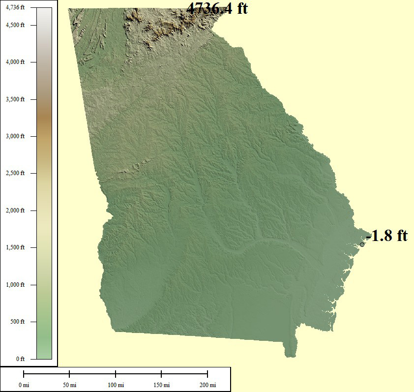
92,786 sq mi
Brasstown Bald - 4,784ft, Atlantic Ocean - 0ft
Creative Commons License
Green/Brown Shading with High/Low Points
Lowest points may include strip mines significantly lower than surrounding area
Medium resolution JPG 842x797:
Preview | Download FREE
High resolution JPG 2317x2458:
Watermarked Preview | Add to Cart $0.99
Ultra resolution JPG 5319x6013:
Watermarked Preview | Add to Cart $1.99
Download the National Elevation Dataset

Select one of the options below if you would like to download the elevation data used to create this map.

30m GMG (133.7 MB) Preview | Add to cart $19.99
View Cart | Checkout

Select another state or map style
Hawaii (HI)

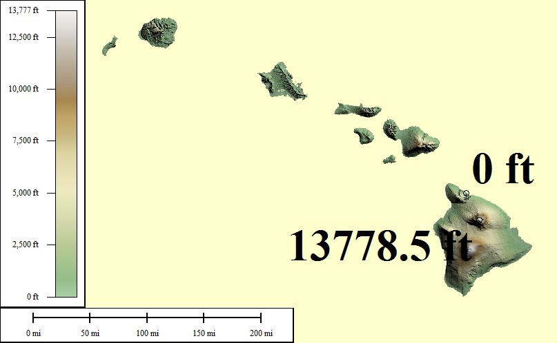
86,232 sq mi
Mauna Kea - 13,803ft, Pacific Ocean - 0ft
Creative Commons License
Green/Brown Shading with High/Low Points
Lowest points may include strip mines significantly lower than surrounding area
Medium resolution JPG 807x498:
Preview | Download FREE
High resolution JPG 2289x1473:
Watermarked Preview | Add to Cart $0.99
Ultra resolution JPG 5399x3561:
Watermarked Preview | Add to Cart $1.99
Download the National Elevation Dataset

Select one of the options below if you would like to download the elevation data used to create this map.

10m GMG (106.2 MB) Preview | Add to cart $24.99
View Cart | Checkout

Select another state or map style
Iowa (IA)

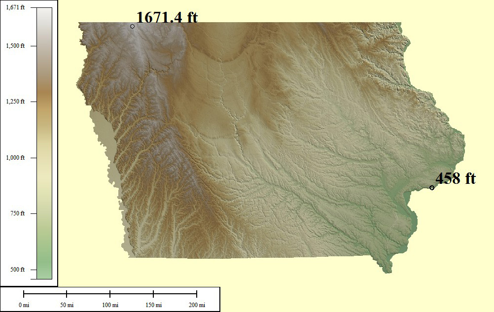
75,412 sq mi
Hawkeye Point - 1,670ft, Mississippi River - 480ft
Creative Commons License
Green/Brown Shading with High/Low Points
Lowest points may include strip mines significantly lower than surrounding area
Medium resolution JPG 1002x633:
Preview | Download FREE
High resolution JPG 2794x1859:
Watermarked Preview | Add to Cart $0.99
Ultra resolution JPG 6791x4461:
Watermarked Preview | Add to Cart $1.99
Download the National Elevation Dataset

Select one of the options below if you would like to download the elevation data used to create this map.

30m GMG (147.4 MB) Preview | Add to cart $19.99
View Cart | Checkout

Select another state or map style
Idaho (ID)

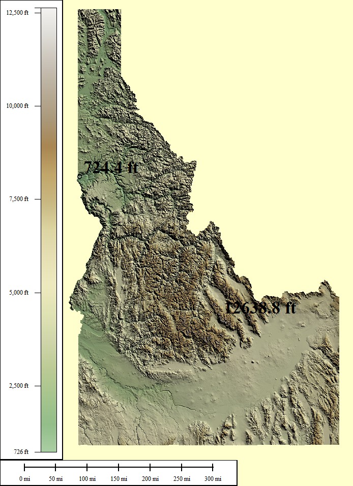
154,028 sq mi
Borah Peak - 12,668ft, Snake River - 724ft
Creative Commons License
Green/Brown Shading with High/Low Points
Lowest points may include strip mines significantly lower than surrounding area
Medium resolution JPG 694x955:
Preview | Download FREE
High resolution JPG 1964x2953:
Watermarked Preview | Add to Cart $0.99
Ultra resolution JPG 4595x7235:
Watermarked Preview | Add to Cart $1.99
Download the National Elevation Dataset

Select one of the options below if you would like to download the elevation data used to create this map.

30m GMG (278.9 MB) Preview | Add to cart $19.99
View Cart | Checkout

Select another state or map style
Illinois (IL)

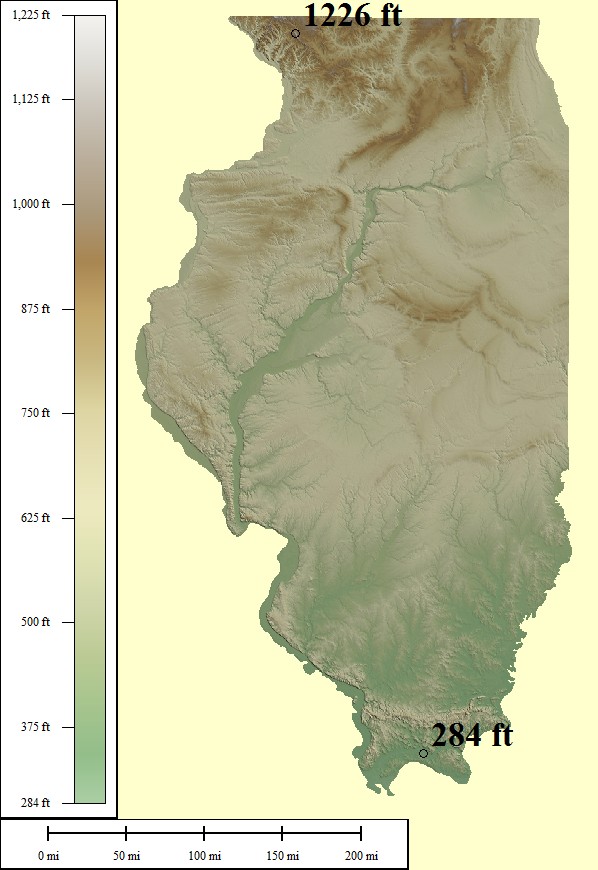
95,503 sq mi
Charles Mound - 1,235ft, Mississippi River - 279ft
Creative Commons License
Green/Brown Shading with High/Low Points
Lowest points may include strip mines significantly lower than surrounding area
Medium resolution JPG 598x870:
Preview | Download FREE
High resolution JPG 1629x2689:
Watermarked Preview | Add to Cart $0.99
Ultra resolution JPG 3826x6585:
Watermarked Preview | Add to Cart $1.99
Download the National Elevation Dataset

Select one of the options below if you would like to download the elevation data used to create this map.

30m GMG (128.9 MB) Preview | Add to cart $19.99
View Cart | Checkout

Select another state or map style
Indiana (IN)

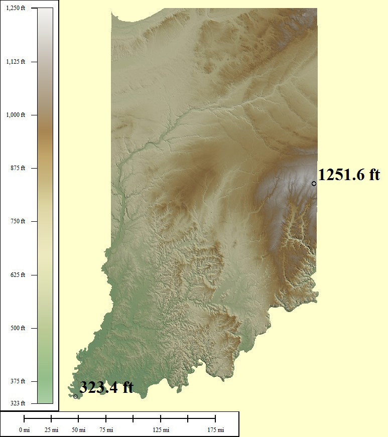
57,317 sq mi
Hoosier Hill - 1,257ft, Ohio River - 320ft
Creative Commons License
Green/Brown Shading with High/Low Points
Lowest points may include strip mines significantly lower than surrounding area
Medium resolution JPG 773x871:
Preview | Download FREE
High resolution JPG 2025x2689:
Watermarked Preview | Add to Cart $0.99
Ultra resolution JPG 4472x6586:
Watermarked Preview | Add to Cart $1.99
Download the National Elevation Dataset

Select one of the options below if you would like to download the elevation data used to create this map.

30m GMG (88.5 MB) Preview | Add to cart $14.99
View Cart | Checkout

Select another state or map style
Kansas (KS)

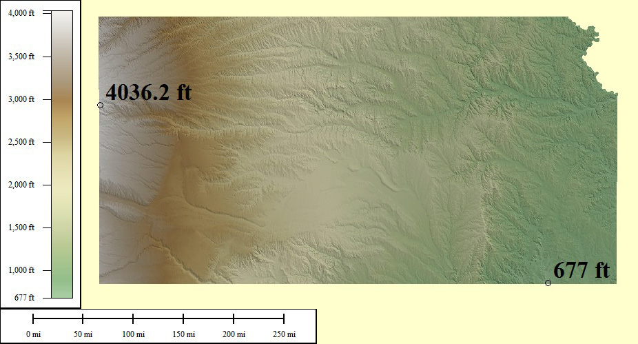
85,498 sq mi
Mt Sunflower - 4,039ft, Verdigris River - 679ft
Creative Commons License
Green/Brown Shading with High/Low Points
Lowest points may include strip mines significantly lower than surrounding area
Medium resolution JPG 926x499:
Preview | Download FREE
High resolution JPG 2693x1402:
Watermarked Preview | Add to Cart $0.99
Ultra resolution JPG 6432x3334:
Watermarked Preview | Add to Cart $1.99
Download the National Elevation Dataset

Select one of the options below if you would like to download the elevation data used to create this map.

30m GMG (195.8 MB) Preview | Add to cart $19.99
View Cart | Checkout

Select another state or map style
Kentucky (KY)

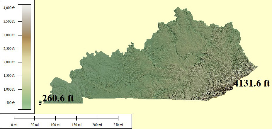
77,240 sq mi
Black Mountain - 4,145ft, Mississippi River - 257ft
Creative Commons License
Green/Brown Shading with High/Low Points
Lowest points may include strip mines significantly lower than surrounding area
Medium resolution JPG 928x440:
Preview | Download FREE
High resolution JPG 2669x1207:
Watermarked Preview | Add to Cart $0.99
Ultra resolution JPG 6434x2850:
Watermarked Preview | Add to Cart $1.99
Download the National Elevation Dataset

Select one of the options below if you would like to download the elevation data used to create this map.

30m GMG (122.3 MB) Preview | Add to cart $19.99
View Cart | Checkout

Select another state or map style
Louisiana (LA)

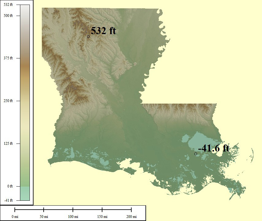
89,981 sq mi
Driskill Mountain - 535ft, New Orleans - (-8ft)
Creative Commons License
Green/Brown Shading with High/Low Points
Lowest points may include strip mines significantly lower than surrounding area
Medium resolution JPG 852x719:
Preview | Download FREE
High resolution JPG 2439x2164:
Watermarked Preview | Add to Cart $0.99
Ultra resolution JPG 5874x5268:
Watermarked Preview | Add to Cart $1.99
Download the National Elevation Dataset

Select one of the options below if you would like to download the elevation data used to create this map.

30m GMG (88.8 MB) Preview | Add to cart $19.99
View Cart | Checkout

Select another state or map style
Massachussetts (MA)

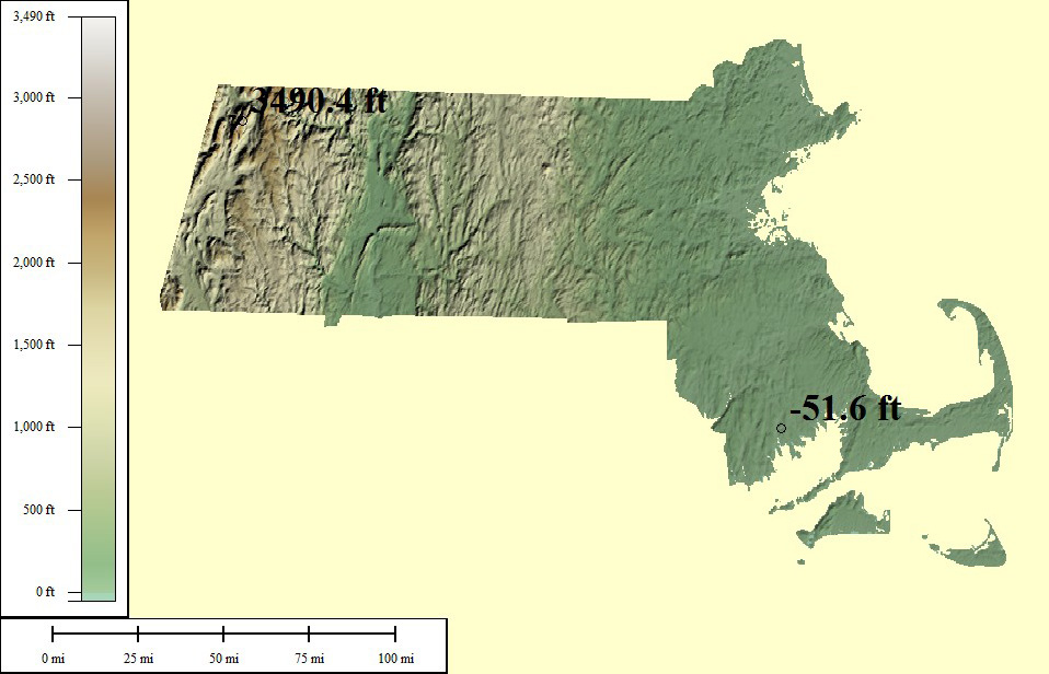
22,149 sq mi
Mt Greylock - 3,492ft, Atlantic Ocean - 0ft
Creative Commons License
Green/Brown Shading with High/Low Points
Lowest points may include strip mines significantly lower than surrounding area
Medium resolution JPG 958x616:
Preview | Download FREE
High resolution JPG 2879x1757:
Watermarked Preview | Add to Cart $0.99
Ultra resolution JPG 6735x4202:
Watermarked Preview | Add to Cart $1.99
Download the National Elevation Dataset

Select one of the options below if you would like to download the elevation data used to create this map.

30m GMG (24 MB) Preview | Add to cart $9.99
View Cart | Checkout

Select another state or map style
Maryland (MD)

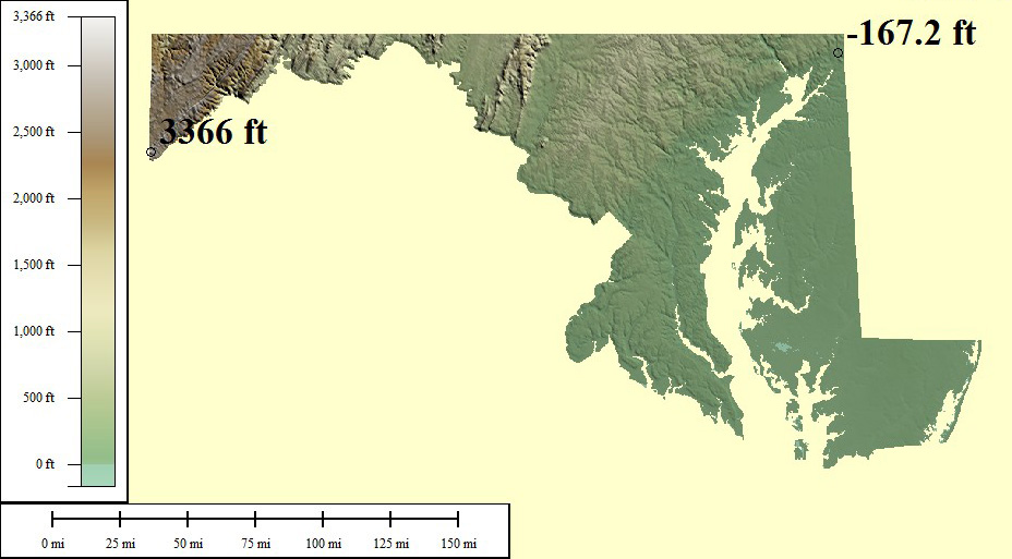
30,920 sq mi
Hoye-Crest - 3,360ft, Atlantic Ocean - 0ft
Creative Commons License
Green/Brown Shading with High/Low Points
Lowest points may include strip mines significantly lower than surrounding area
Medium resolution JPG 928x513:
Preview | Download FREE
High resolution JPG 2718x1412:
Watermarked Preview | Add to Cart $0.99
Ultra resolution JPG 6452x3356:
Watermarked Preview | Add to Cart $1.99
Download the National Elevation Dataset

Select one of the options below if you would like to download the elevation data used to create this map.

30m GMG (27.2 MB) Preview | Add to cart $9.99
View Cart | Checkout

Select another state or map style
Maine (ME)

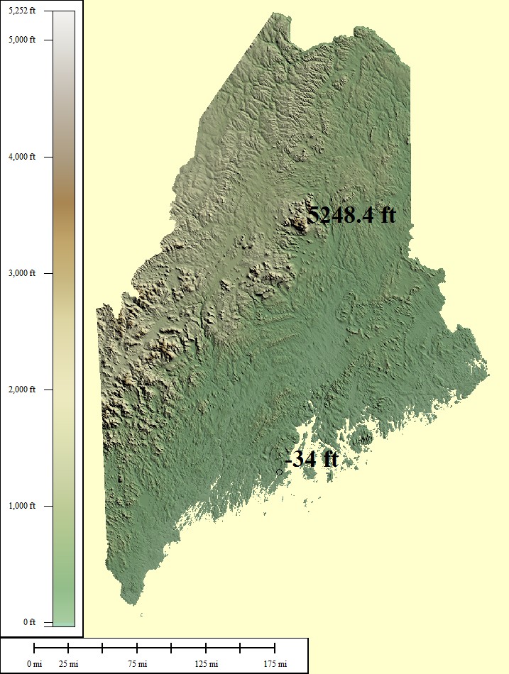
65,426 sq mi
Mt Katahdin - 5,268ft, Atlantic Ocean - 0ft
Creative Commons License
Green/Brown Shading with High/Low Points
Lowest points may include strip mines significantly lower than surrounding area
Medium resolution JPG 717x950:
Preview | Download FREE
High resolution JPG 2032x2937:
Watermarked Preview | Add to Cart $0.99
Ultra resolution JPG 4790x7192:
Watermarked Preview | Add to Cart $1.99
Download the National Elevation Dataset

Select one of the options below if you would like to download the elevation data used to create this map.

30m GMG (152.3 MB) Preview | Add to cart $14.99
View Cart | Checkout

Select another state or map style
Michigan (MI)

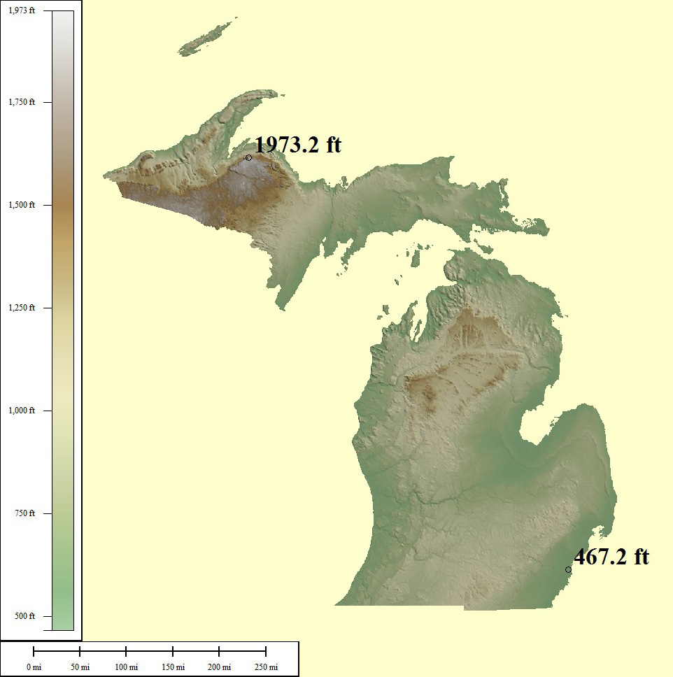
197,037 sq mi
Mt Arvon - 1,979ft, Lake Erie - 571ft
Creative Commons License
Green/Brown Shading with High/Low Points
Lowest points may include strip mines significantly lower than surrounding area
Medium resolution JPG 962x968:
Preview | Download FREE
High resolution JPG 2717x2953:
Watermarked Preview | Add to Cart $0.99
Ultra resolution JPG 6320x7197:
Watermarked Preview | Add to Cart $1.99
Download the National Elevation Dataset

Select one of the options below if you would like to download the elevation data used to create this map.

30m GMG (210.9 MB) Preview | Add to cart $19.99
View Cart | Checkout

Select another state or map style
Minnesota (MN)

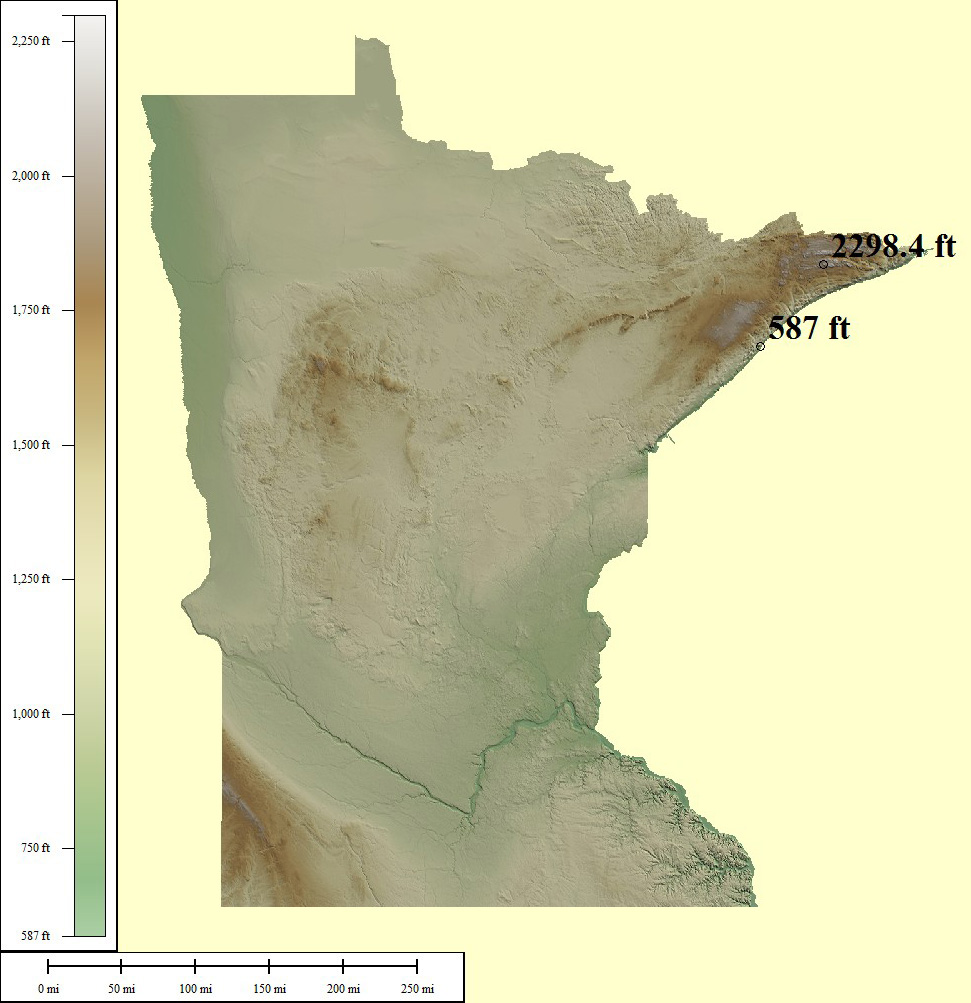
157,760 sq mi
Eagle Mountain - 2,301ft, Lake Superior - 601ft
Creative Commons License
Green/Brown Shading with High/Low Points
Lowest points may include strip mines significantly lower than surrounding area
Medium resolution JPG 971x1003:
Preview | Download FREE
High resolution JPG 2807x3035:
Watermarked Preview | Add to Cart $0.99
Ultra resolution JPG 6814x7389:
Watermarked Preview | Add to Cart $1.99
Download the National Elevation Dataset

Select one of the options below if you would like to download the elevation data used to create this map.

30m GMG (191 MB) Preview | Add to cart $19.99
View Cart | Checkout

Select another state or map style
Missouri (MO)

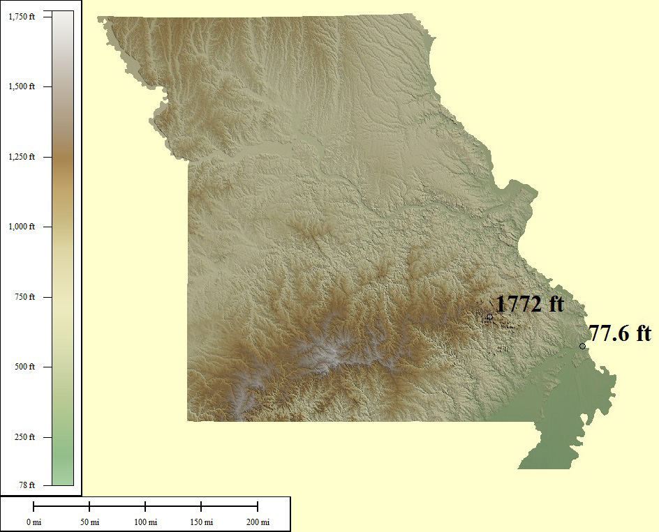
120,485 sq mi
Taum Sauk Mtn - 1,772ft, St Francis River - 230ft
Creative Commons License
Green/Brown Shading with High/Low Points
Lowest points may include strip mines significantly lower than surrounding area
Medium resolution JPG 944x763:
Preview | Download FREE
High resolution JPG 2628x2258:
Watermarked Preview | Add to Cart $0.99
Ultra resolution JPG 6322x5478:
Watermarked Preview | Add to Cart $1.99
Download the National Elevation Dataset

Select one of the options below if you would like to download the elevation data used to create this map.

30m GMG (188 MB) Preview | Add to cart $19.99
View Cart | Checkout

Select another state or map style
Mississippi (MS)

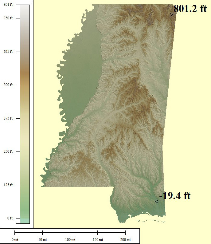
76,655 sq mi
Woodall Mountain - 807ft, Gulf of Mexico - 0ft
Creative Commons License
Green/Brown Shading with High/Low Points
Lowest points may include strip mines significantly lower than surrounding area
Medium resolution JPG 687x794:
Preview | Download FREE
High resolution JPG 1765x2452:
Watermarked Preview | Add to Cart $0.99
Ultra resolution JPG 3912x6003:
Watermarked Preview | Add to Cart $1.99
Download the National Elevation Dataset

Select one of the options below if you would like to download the elevation data used to create this map.

30m GMG (114.2 MB) Preview | Add to cart $19.99
View Cart | Checkout

Select another state or map style
Montana (MT)

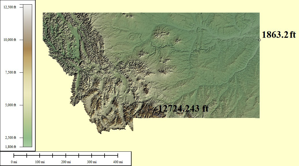
218,830 sq mi
Granite Peak - 12,807ft, Kootenai River - 1,800ft
Creative Commons License
Green/Brown Shading with High/Low Points
Lowest points may include strip mines significantly lower than surrounding area
Medium resolution JPG 1041x580:
Preview | Download FREE
High resolution JPG 2912x1603:
Watermarked Preview | Add to Cart $0.99
Ultra resolution JPG 6711x3794:
Watermarked Preview | Add to Cart $1.99
Download the National Elevation Dataset

Select one of the options below if you would like to download the elevation data used to create this map.

30m GMG (473 MB) Preview | Add to cart $19.99
View Cart | Checkout

Select another state or map style
North Carolina (NC)

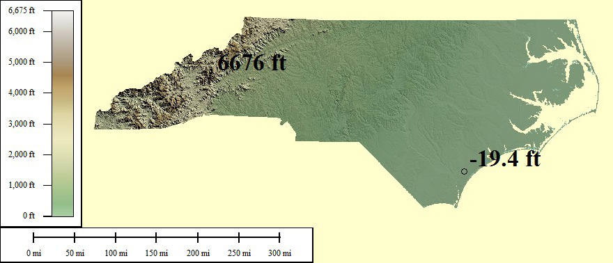
96,798 sq mi
Mt Mitchell - 6,684ft, Atlantic Ocean - 0ft
Creative Commons License
Green/Brown Shading with High/Low Points
Lowest points may include strip mines significantly lower than surrounding area
Medium resolution JPG 880x378:
Preview | Download FREE
High resolution JPG 2567x1012:
Watermarked Preview | Add to Cart $0.99
Ultra resolution JPG 6228x2373:
Watermarked Preview | Add to Cart $1.99
Download the National Elevation Dataset

Select one of the options below if you would like to download the elevation data used to create this map.

30m GMG (123.9 MB) Preview | Add to cart $19.99
View Cart | Checkout

Select another state or map style
North Dakota (ND)

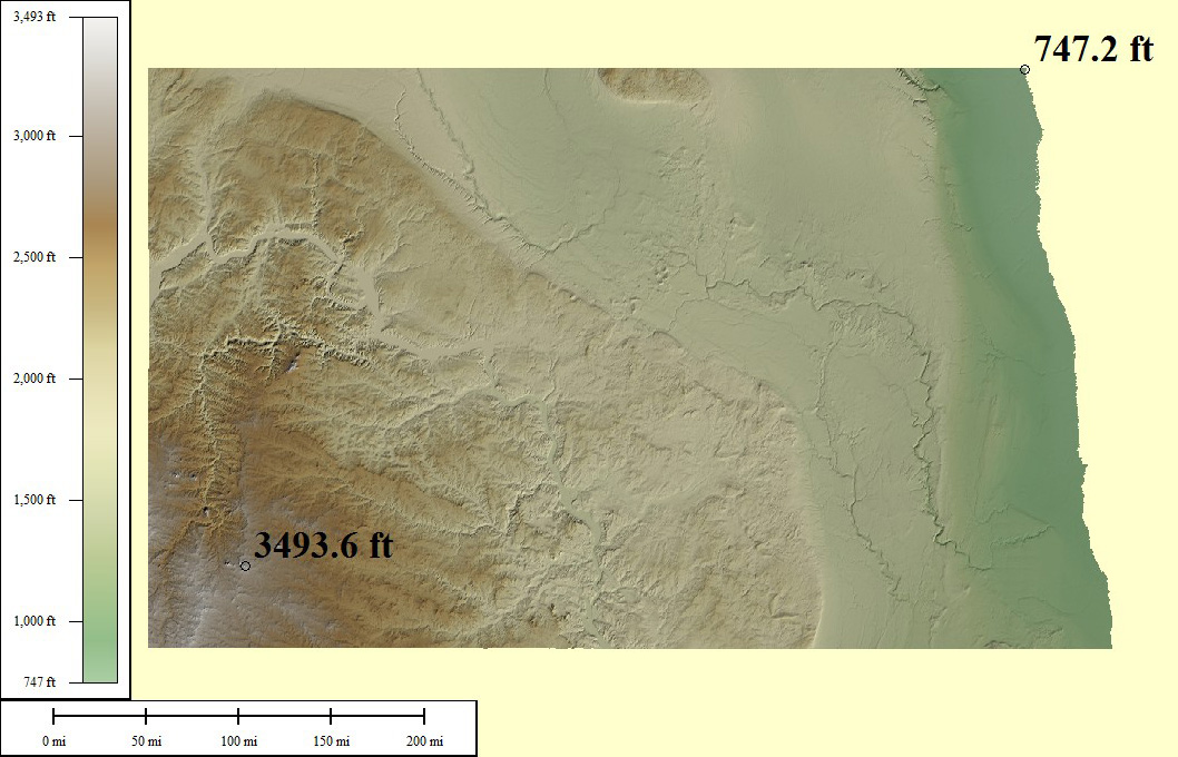
77,387 sq mi
White Butte - 3,506ft, Red River - 750ft
Creative Commons License
Green/Brown Shading with High/Low Points
Lowest points may include strip mines significantly lower than surrounding area
Medium resolution JPG 1058x680:
Preview | Download FREE
High resolution JPG 3050x1918:
Watermarked Preview | Add to Cart $0.99
Ultra resolution JPG 7438x4571:
Watermarked Preview | Add to Cart $1.99
Download the National Elevation Dataset

Select one of the options below if you would like to download the elevation data used to create this map.

30m GMG (181.4 MB) Preview | Add to cart $19.99
View Cart | Checkout

Select another state or map style
Nebraska (NE)

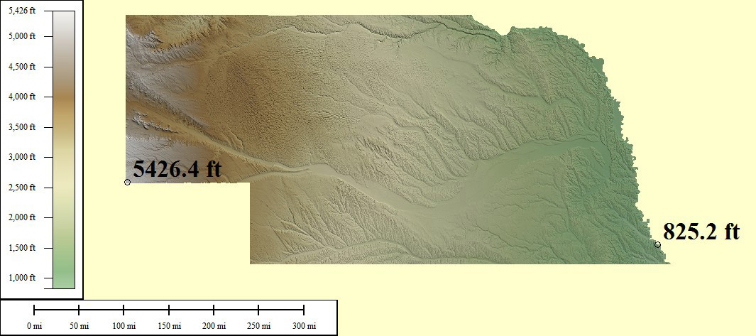
98,017 sq mi
Panorama Point - 5,424ft, Missouri River - 840ft
Creative Commons License
Green/Brown Shading with High/Low Points
Lowest points may include strip mines significantly lower than surrounding area
Medium resolution JPG 1065x473:
Preview | Download FREE
High resolution JPG 2846x1292:
Watermarked Preview | Add to Cart $0.99
Ultra resolution JPG 6650x3044:
Watermarked Preview | Add to Cart $1.99
Download the National Elevation Dataset

Select one of the options below if you would like to download the elevation data used to create this map.

30m GMG (202.6 MB) Preview | Add to cart $19.99
View Cart | Checkout

Select another state or map style
New Hampshire (NH)

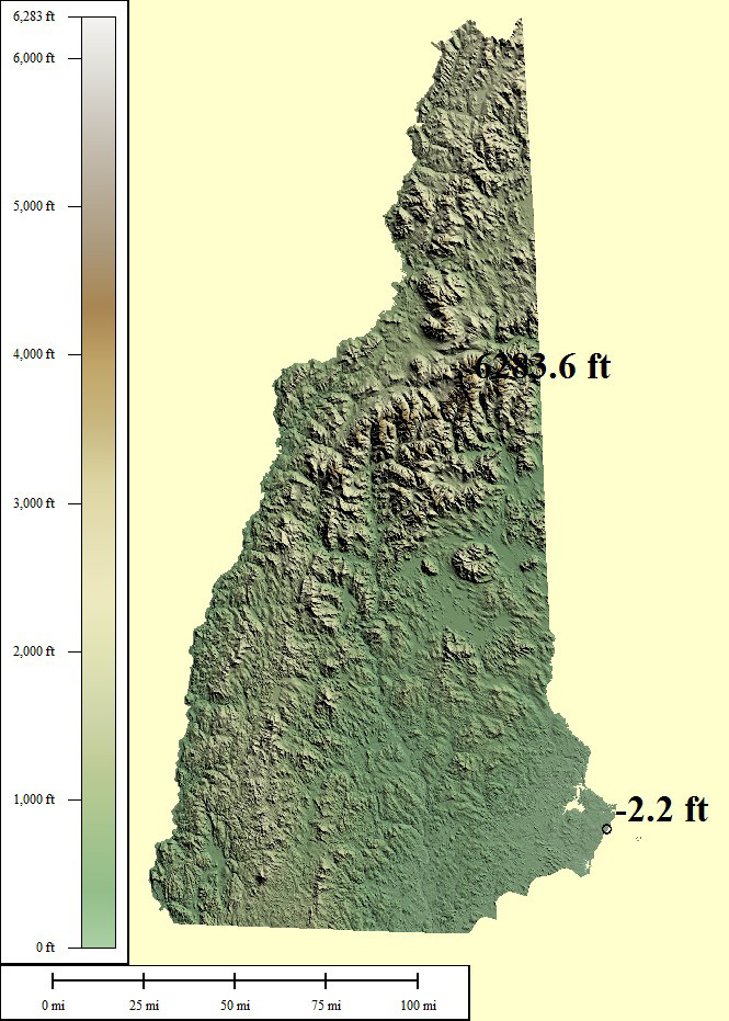
18,076 sq mi
Mt Washington - 6,288ft, Atlantic Ocean - 0ft
Creative Commons License
Green/Brown Shading with High/Low Points
Lowest points may include strip mines significantly lower than surrounding area
Medium resolution JPG 665x931:
Preview | Download FREE
High resolution JPG 1691x2875:
Watermarked Preview | Add to Cart $0.99
Ultra resolution JPG 3920x7039:
Watermarked Preview | Add to Cart $1.99
Download the National Elevation Dataset

Select one of the options below if you would like to download the elevation data used to create this map.

30m GMG (29.1 MB) Preview | Add to cart $9.99
View Cart | Checkout

Select another state or map style
New Jersey (NJ)

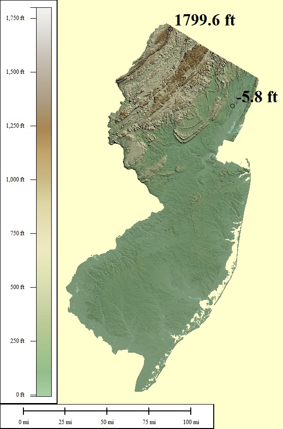
16,097 sq mi
High Point - 1,803ft, Atlantic Ocean - 0ft
Creative Commons License
Green/Brown Shading with High/Low Points
Lowest points may include strip mines significantly lower than surrounding area
Medium resolution JPG 580x877:
Preview | Download FREE
High resolution JPG 1514x2704:
Watermarked Preview | Add to Cart $0.99
Ultra resolution JPG 3560x6620:
Watermarked Preview | Add to Cart $1.99
Download the National Elevation Dataset

Select one of the options below if you would like to download the elevation data used to create this map.

30m GMG (17.9 MB) Preview | Add to cart $9.99
View Cart | Checkout

Select another state or map style
New Mexico (NM)

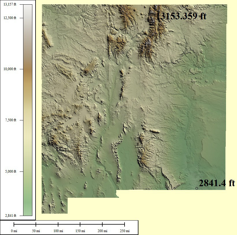
139,582 sq mi
Wheeler Peak - 13,167ft, Red Bluff Reservoir - 2,842ft
Creative Commons License
Green/Brown Shading with High/Low Points
Lowest points may include strip mines significantly lower than surrounding area
Medium resolution JPG 820x814:
Preview | Download FREE
High resolution JPG 2311x2503:
Watermarked Preview | Add to Cart $0.99
Ultra resolution JPG 5518x6121:
Watermarked Preview | Add to Cart $1.99
Download the National Elevation Dataset

Select one of the options below if you would like to download the elevation data used to create this map.

10m GMG (1.96 GB) Preview | Add to cart $24.99
30m GMG (303.4 MB) Preview | Add to cart $19.99
View Cart | Checkout

Select another state or map style
Nevada (NV)

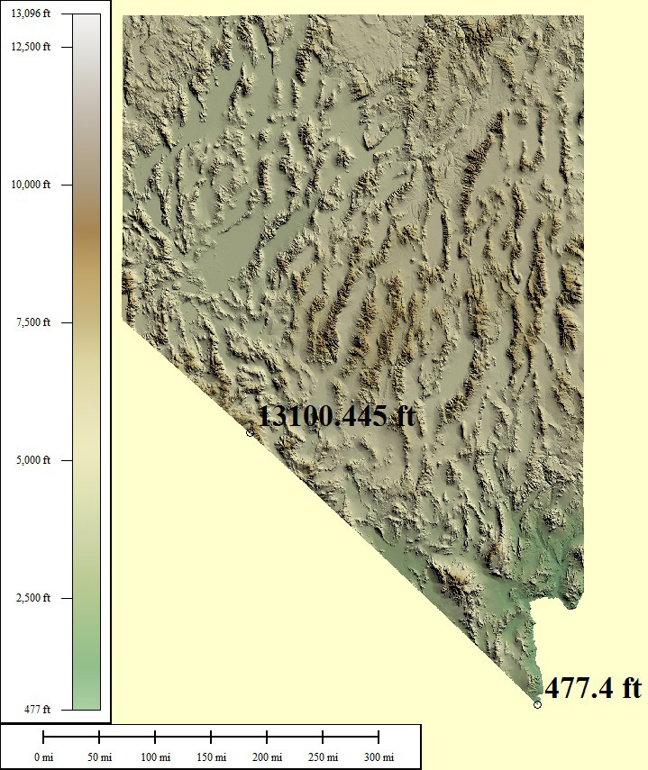
163,065 sq mi
Boundary Peak - 13,441ft, Colorado River - 479ft
Creative Commons License
Green/Brown Shading with High/Low Points
Lowest points may include strip mines significantly lower than surrounding area
Medium resolution JPG 719x855:
Preview | Download FREE
High resolution JPG 1899x2642:
Watermarked Preview | Add to Cart $0.99
Ultra resolution JPG 4441x6472:
Watermarked Preview | Add to Cart $1.99
Download the National Elevation Dataset

Select one of the options below if you would like to download the elevation data used to create this map.

30m GMG (310.7 MB) Preview | Add to cart $19.99
View Cart | Checkout

Select another state or map style
New York (NY)

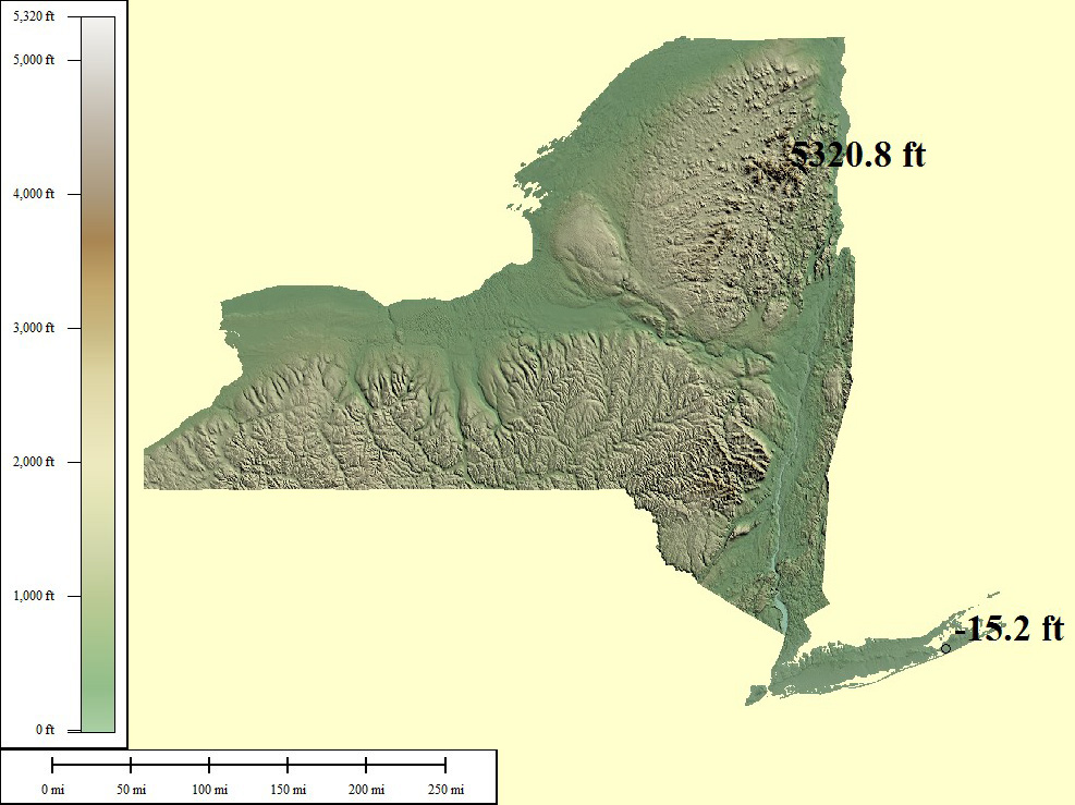
131,120 sq mi
Mt Marcy - 5,344ft, Atlantic Ocean - 0ft
Creative Commons License
Green/Brown Shading with High/Low Points
Lowest points may include strip mines significantly lower than surrounding area
Medium resolution JPG 987x739:
Preview | Download FREE
High resolution JPG 2773x2146:
Watermarked Preview | Add to Cart $0.99
Ultra resolution JPG 6726x5177:
Watermarked Preview | Add to Cart $1.99
Download the National Elevation Dataset

Select one of the options below if you would like to download the elevation data used to create this map.

30m GMG (140.2 MB) Preview | Add to cart $19.99
View Cart | Checkout

Select another state or map style
Ohio (OH)

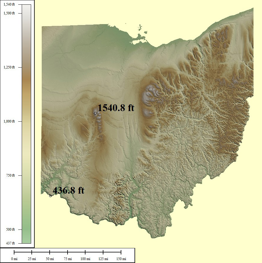
64,418 sq mi
Campbell Hill - 1,550ft, Ohio River - 455ft
Creative Commons License
Green/Brown Shading with High/Low Points
Lowest points may include strip mines significantly lower than surrounding area
Medium resolution JPG 892x895:
Preview | Download FREE
High resolution JPG 2388x2724:
Watermarked Preview | Add to Cart $0.99
Ultra resolution JPG 5809x6655:
Watermarked Preview | Add to Cart $1.99
Download the National Elevation Dataset

Select one of the options below if you would like to download the elevation data used to create this map.

30m GMG (106.1 MB) Preview | Add to cart $14.99
View Cart | Checkout

Select another state or map style
Oklahoma (OK)

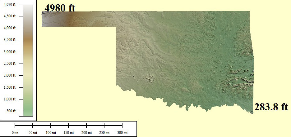
125,166 sq mi
Black Mesa - 4,973ft, Little River - 289ft
Creative Commons License
Green/Brown Shading with High/Low Points
Lowest points may include strip mines significantly lower than surrounding area
Medium resolution JPG 936x442:
Preview | Download FREE
High resolution JPG 2605x1230:
Watermarked Preview | Add to Cart $0.99
Ultra resolution JPG 6040x2920:
Watermarked Preview | Add to Cart $1.99
Download the National Elevation Dataset

Select one of the options below if you would like to download the elevation data used to create this map.

30m GMG (168.8 MB) Preview | Add to cart $19.99
View Cart | Checkout

Select another state or map style
Oregon (OR)

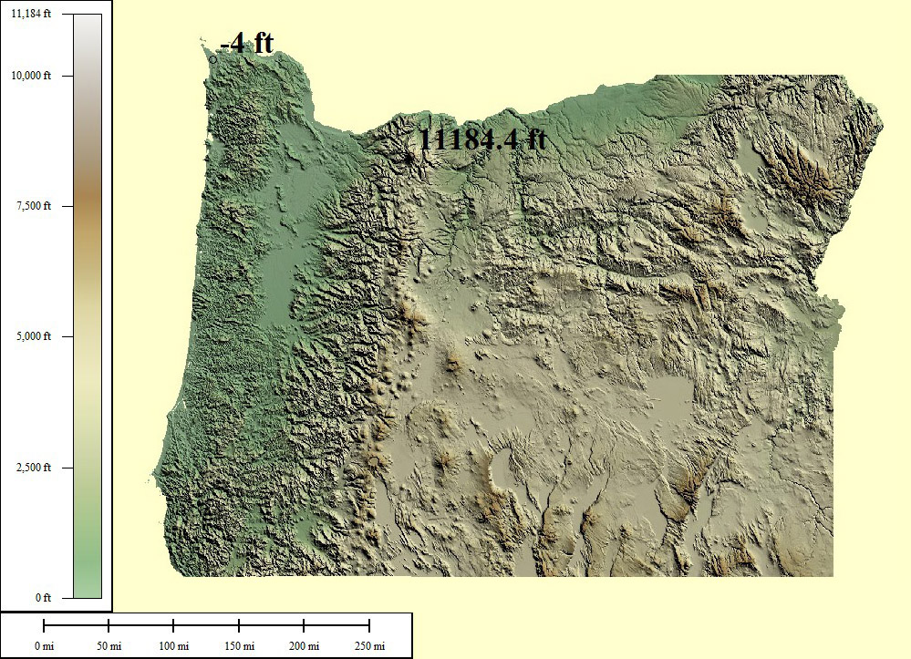
124,505 sq mi
Mt Hood - 11,249ft, Pacific Ocean - 0ft
Creative Commons License
Green/Brown Shading with High/Low Points
Lowest points may include strip mines significantly lower than surrounding area
Medium resolution JPG 999x723:
Preview | Download FREE
High resolution JPG 2848x2104:
Watermarked Preview | Add to Cart $0.99
Ultra resolution JPG 6960x5062:
Watermarked Preview | Add to Cart $1.99
Download the National Elevation Dataset

Select one of the options below if you would like to download the elevation data used to create this map.

30m GMG (313.4 MB) Preview | Add to cart $19.99
View Cart | Checkout

Select another state or map style
Pennsylvania (PA)

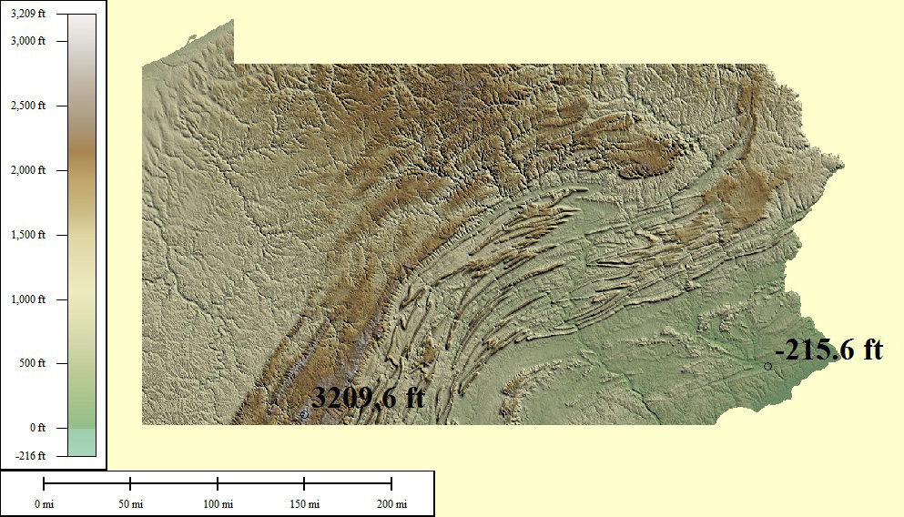
58,094 sq mi
Mt Davis - 3,213ft, Delaware River - 0ft
Creative Commons License
Green/Brown Shading with High/Low Points
Lowest points may include strip mines significantly lower than surrounding area
Medium resolution JPG 993x568:
Preview | Download FREE
High resolution JPG 2568x1471:
Watermarked Preview | Add to Cart $0.99
Ultra resolution JPG 6166x3551:
Watermarked Preview | Add to Cart $1.99
Download the National Elevation Dataset

Select one of the options below if you would like to download the elevation data used to create this map.

30m GMG (136.5 MB) Preview | Add to cart $14.99
View Cart | Checkout

Select another state or map style
Rhode Island (RI)

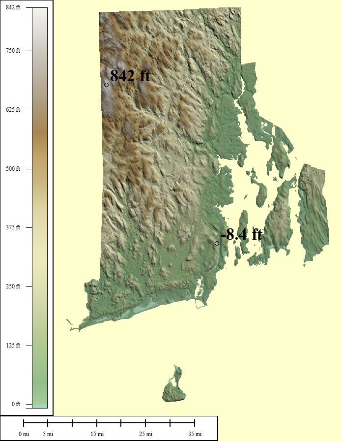
2,818 sq mi
Jerimoth Hill - 812ft, Atlantic Ocean - 0ft
Creative Commons License
Green/Brown Shading with High/Low Points
Lowest points may include strip mines significantly lower than surrounding area
Medium resolution JPG 696x896:
Preview | Download FREE
High resolution JPG 1914x2763:
Watermarked Preview | Add to Cart $0.99
Ultra resolution JPG 4574x6766:
Watermarked Preview | Add to Cart $1.99
Download the National Elevation Dataset

Select one of the options below if you would like to download the elevation data used to create this map.

30m GMG (3.3 MB) Preview | Add to cart $9.99
View Cart | Checkout

Select another state or map style
South Carolina (SC)

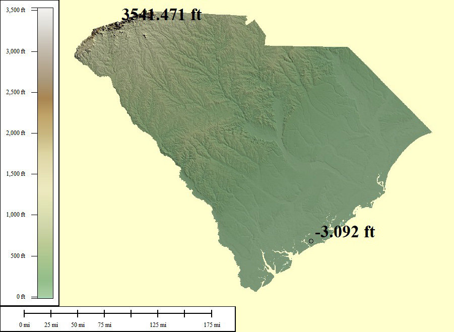
62,118 sq mi
Sassafras Mountain - 3,560ft, Atlantic Ocean - 0ft
Creative Commons License
Green/Brown Shading with High/Low Points
Lowest points may include strip mines significantly lower than surrounding area
Medium resolution JPG 901x659:
Preview | Download FREE
High resolution JPG 2506x1947:
Watermarked Preview | Add to Cart $0.99
Ultra resolution JPG 6101x4716:
Watermarked Preview | Add to Cart $1.99
Download the National Elevation Dataset

Select one of the options below if you would like to download the elevation data used to create this map.

30m GMG (88.3 MB) Preview | Add to cart $14.99
View Cart | Checkout

Select another state or map style
South Dakota (SD)

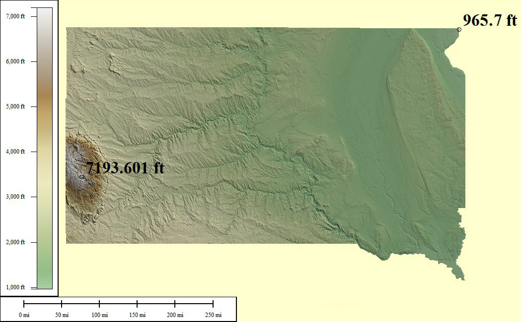
96,750 sq mi
Harney Peak - 7,244ft, Big Stone Lake - 966ft
Creative Commons License
Green/Brown Shading with High/Low Points
Lowest points may include strip mines significantly lower than surrounding area
Medium resolution JPG 1049x650:
Preview | Download FREE
High resolution JPG 2948x1881:
Watermarked Preview | Add to Cart $0.99
Ultra resolution JPG 6932x4503:
Watermarked Preview | Add to Cart $1.99
Download the National Elevation Dataset

Select one of the options below if you would like to download the elevation data used to create this map.

30m GMG (200.9 MB) Preview | Add to cart $19.99
View Cart | Checkout

Select another state or map style
Tennessee (TN)

57,342 sq mi
Clingmans Dome - 6,643ft, Mississippi River - 178ft
Creative Commons License
Green/Brown Shading with High/Low Points
Lowest points may include strip mines significantly lower than surrounding area
Medium resolution JPG 932x283:
Preview | Download FREE
High resolution JPG 2597x695:
Watermarked Preview | Add to Cart $0.99
Ultra resolution JPG 6314x1577:
Watermarked Preview | Add to Cart $1.99
Download the National Elevation Dataset

Select one of the options below if you would like to download the elevation data used to create this map.

30m GMG (120.3 MB) Preview | Add to cart $14.99
View Cart | Checkout

Select another state or map style
Texas (TX)

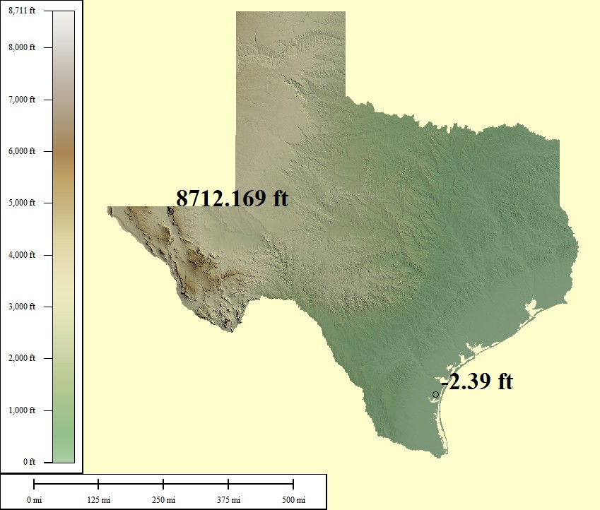
600,862 sq mi
Guadalupe Peak - 8,751ft, Gulf of Mexico - 0ft
Creative Commons License
Green/Brown Shading with High/Low Points
Lowest points may include strip mines significantly lower than surrounding area
Medium resolution JPG 849x722:
Preview | Download FREE
High resolution JPG 2375x2198:
Watermarked Preview | Add to Cart $0.99
Ultra resolution JPG 5748x5360:
Watermarked Preview | Add to Cart $1.99
Download the National Elevation Dataset

Select one of the options below if you would like to download the elevation data used to create this map.

30m GMG (995 MB) Preview | Add to cart $24.99
View Cart | Checkout

Select another state or map style
Utah (UT)

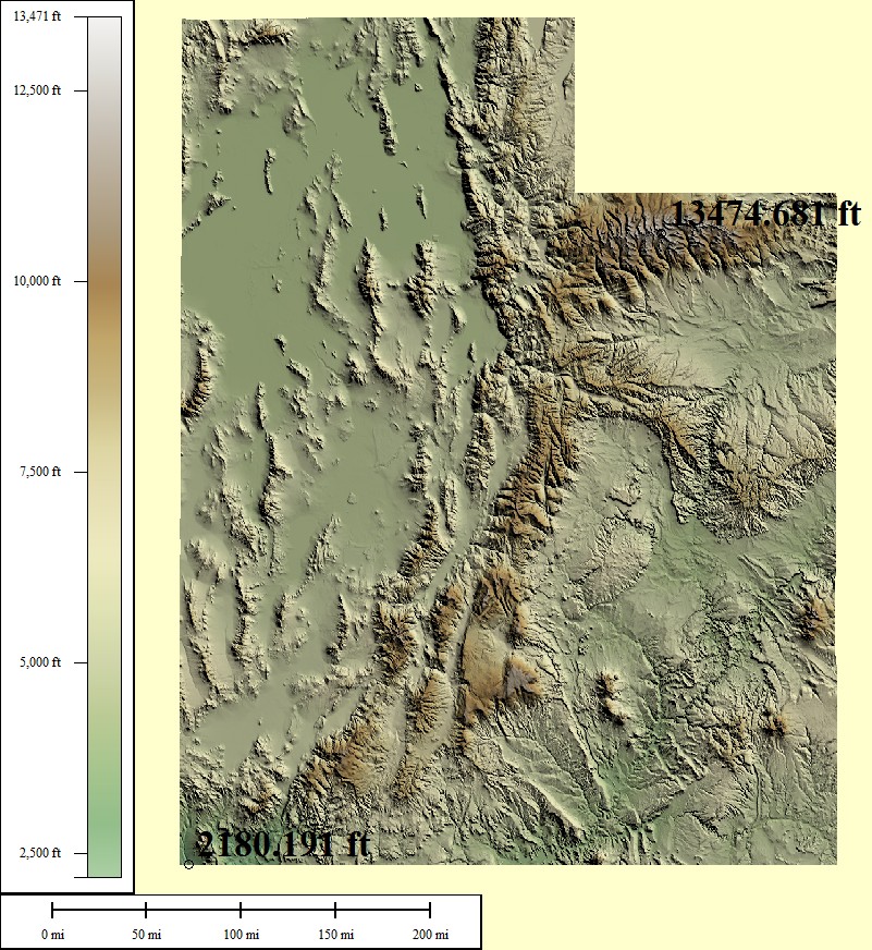
100,045 sq mi
Kings Peak - 13,528ft, Beaver Dam Wash - 2,000ft
Creative Commons License
Green/Brown Shading with High/Low Points
Lowest points may include strip mines significantly lower than surrounding area
Medium resolution JPG 801x872:
Preview | Download FREE
High resolution JPG 2205x2684:
Watermarked Preview | Add to Cart $0.99
Ultra resolution JPG 5252x6566:
Watermarked Preview | Add to Cart $1.99
Download the National Elevation Dataset

Select one of the options below if you would like to download the elevation data used to create this map.

30m GMG (244.4 MB) Preview | Add to cart $19.99
View Cart | Checkout

Select another state or map style
Virginia (VA)

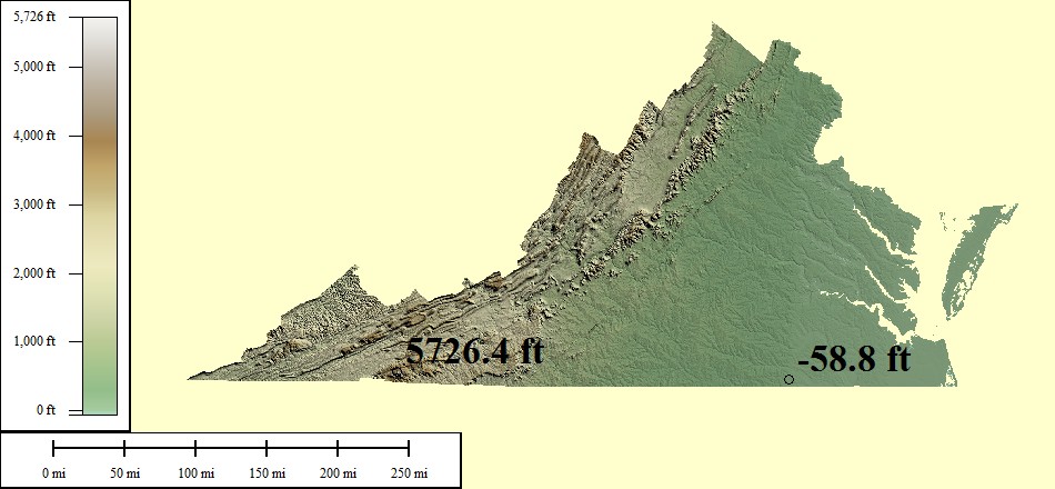
94,898 sq mi
Mt Rogers - 5,729ft, Atlantic Ocean - 0ft
Creative Commons License
Green/Brown Shading with High/Low Points
Lowest points may include strip mines significantly lower than surrounding area
Medium resolution JPG 950x440:
Preview | Download FREE
High resolution JPG 2642x1201:
Watermarked Preview | Add to Cart $0.99
Ultra resolution JPG 6439x2834:
Watermarked Preview | Add to Cart $1.99
Download the National Elevation Dataset

Select one of the options below if you would like to download the elevation data used to create this map.

30m GMG (117.5 MB) Preview | Add to cart $19.99
View Cart | Checkout

Select another state or map style
Vermont (VT)

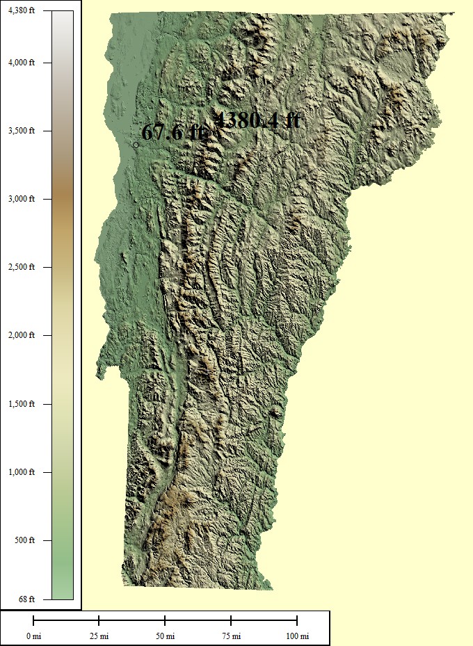
15,823 sq mi
Mt Mansfield - 4,395ft, Lake Champlain - 95ft
Creative Commons License
Green/Brown Shading with High/Low Points
Lowest points may include strip mines significantly lower than surrounding area
Medium resolution JPG 680x929:
Preview | Download FREE
High resolution JPG 1889x2869:
Watermarked Preview | Add to Cart $0.99
Ultra resolution JPG 4478x7024:
Watermarked Preview | Add to Cart $1.99
Download the National Elevation Dataset

Select one of the options below if you would like to download the elevation data used to create this map.

30m GMG (31.4 MB) Preview | Add to cart $9.99
View Cart | Checkout

Select another state or map style
Washington (WA)

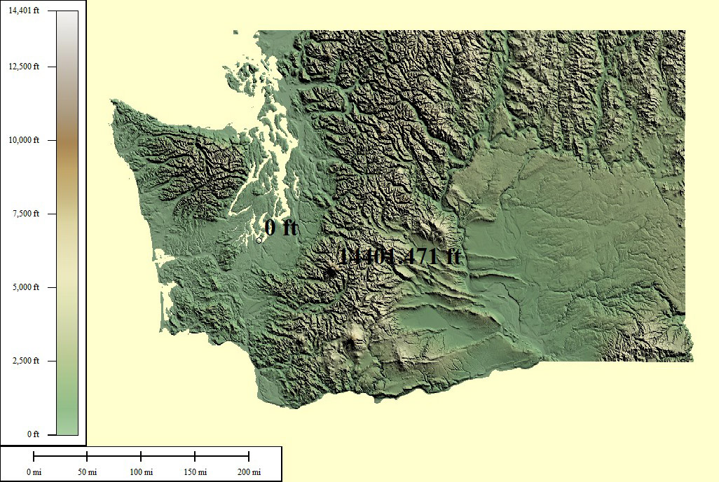
93,010 sq mi
Mt Rainier - 14,410ft, Pacific Ocean - 0ft
Creative Commons License
Green/Brown Shading with High/Low Points
Lowest points may include strip mines significantly lower than surrounding area
Medium resolution JPG 1026x688:
Preview | Download FREE
High resolution JPG 2957x1949:
Watermarked Preview | Add to Cart $0.99
Ultra resolution JPG 7197x4651:
Watermarked Preview | Add to Cart $1.99
Download the National Elevation Dataset

Select one of the options below if you would like to download the elevation data used to create this map.

30m GMG (238.9 MB) Preview | Add to cart $19.99
View Cart | Checkout

Select another state or map style
Wisconsin (WI)

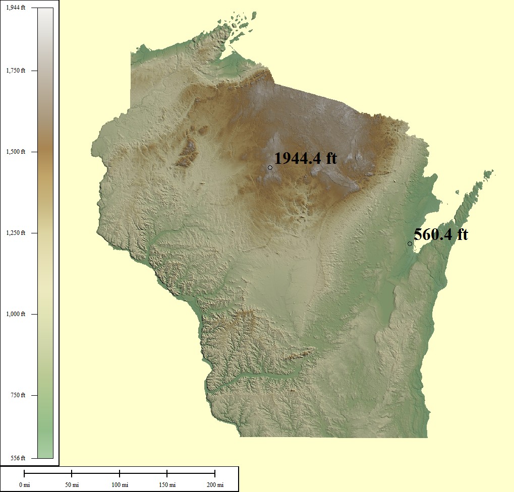
106,799 sq mi
Timms Hill - 1,951ft, Lake Michigan - 579ft
Creative Commons License
Green/Brown Shading with High/Low Points
Lowest points may include strip mines significantly lower than surrounding area
Medium resolution JPG 1019x976:
Preview | Download FREE
High resolution JPG 2765x2901:
Watermarked Preview | Add to Cart $0.99
Ultra resolution JPG 6581x7052:
Watermarked Preview | Add to Cart $1.99
Download the National Elevation Dataset

Select one of the options below if you would like to download the elevation data used to create this map.

30m GMG (242.4 MB) Preview | Add to cart $19.99
View Cart | Checkout

Select another state or map style
West Virginia (WV)

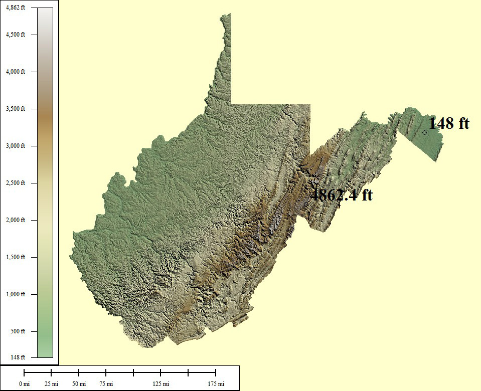
65,069 sq mi
Spruce Knob - 4,863ft, Potomac River - 240ft
Creative Commons License
Green/Brown Shading with High/Low Points
Lowest points may include strip mines significantly lower than surrounding area
Medium resolution JPG 959x780:
Preview | Download FREE
High resolution JPG 2720x2335:
Watermarked Preview | Add to Cart $0.99
Ultra resolution JPG 6428x5667:
Watermarked Preview | Add to Cart $1.99
Download the National Elevation Dataset

Select one of the options below if you would like to download the elevation data used to create this map.

30m GMG (84.7 MB) Preview | Add to cart $14.99
View Cart | Checkout

Select another state or map style
Wyoming (WY)

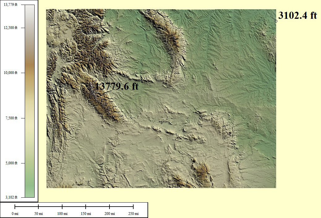
108,284 sq mi
Gannett Peak - 13,809ft, Belle Fourche River - 3,099ft
Creative Commons License
Green/Brown Shading with High/Low Points
Lowest points may include strip mines significantly lower than surrounding area
Medium resolution JPG 1038x707:
Preview | Download FREE
High resolution JPG 2870x2062:
Watermarked Preview | Add to Cart $0.99
Ultra resolution JPG 6639x4964:
Watermarked Preview | Add to Cart $1.99
Download the National Elevation Dataset

Select one of the options below if you would like to download the elevation data used to create this map.

10m GMG (1.84 GB) Preview | Add to cart $24.99
30m GMG (290 MB) Preview | Add to cart $19.99
View Cart | Checkout

Select another state or map style

TERMS OF USE

All maps displayed on this page or downloadable via a "download" link on this page are © 2009 topocreator.com released to the public under a Creative Commons Attribution-Share Alike license. Maps are available for purchase for a small fee for educational, personal, and commercial usage under an alternative license. The elevation data used in the creation of these maps has been obtained through the USGS, NOAA, and the US Census Bureau via the public domain.