Home » View more maps » 2010 Tour de France
2010 Tour de France - July 3-25, 2010 Prologue, STAGES 9-16
Stage 9 | Stage 10 | Stage 11 | Stage 12 | Stage 13 | Stage 14 | Stage 15 | Stage 16
|
Tour de France Stage 9 - Morzine to St Jean-de-Maurienne Stage winner: Sandy Casar, FDJ, in 5h 38' 10" Tuesday, July 13, 2010 |
|
 Print/Download |
 Tour de France Stage 9 - Morzine to St Jean-de-Maurienne (3d) |
|
Tour de France Stage 10 - Chambéry to Gap Stage winner: Sergio Paulinho, Team RadioShack, in 5h 10' 56" Wednesday, July 14, 2010 |
|
 Print/Download |
 Tour de France Stage 10 - Chambéry to Gap (3d) |
|
Tour de France Stage 11 - Sisteron to Bourg-les-Valence Stage winner: Mark Cavendish, Team HTC-Columbia, in 4h 42' 29" Thursday, July 15, 2010 |
|
 Print/Download |
 Tour de France Stage 11 - Sisteron to Bourg-les-Valence (3d) |
|
Tour de France Stage 12 - Bourg de Péage to Mende Stage winner: Joaquim Rodriguez, Katusha Team in 4h 58' 26" Friday, July 16, 2010 |
|
 Print/Download |
 Tour de France Stage 12 - Bourg de Péage to Mende (3d) |
|
Tour de France Stage 13 - Rodez to Revel Stage winner: Alexandre Vinokourov, Astana, in 4h 26' 26" Saturday, July 17, 2010 |
|
 Print/Download |
 Tour de France Stage 13 - Rodez to Revel (3d) |
|
Tour de France Stage 14 - Revel to Ax 3 Domaines Stage winner: Christophe Riblon, Ag2r La Mondiale, in 4h 52' 42" Sunday, July 18, 2010 |
|
 Print/Download |
 Tour de France Stage 14 - Revel to Ax 3 Domaines (3d) |
|
Tour de France Stage 15 - Pamiers to Bagneres de Luchon Stage winner: Thomas Voeckler, BBox Bouygues Telecom,in 4h 44' 51" Monday, July 19, 2010 |
|
 Print/Download |
 |
|
Tour de France Stage 16 - Bagneres de Luchon to Pau Stage winner: Pierrick Fedrigo, BBox Bouygues Telecom, in 5h 31' 43" Tuesday, July 20, 2010 |
|
 Print/Download |
 Tour de France Stage 16 - Bagneres de Luchon to Pau (3d) |
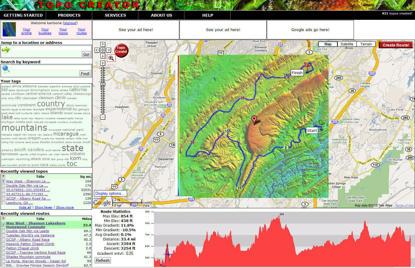
The beta version of topocreator.com is coming soon. Click the screenshot below for a preview!
TERMS OF USE
All maps on this page have been created using the beta version of topocreator.com which is not available to the public yet. The tentative release date for the beta version of topocreator.com is August 2010. The elevation data used in the creation of these maps has been obtained through a variety of sources - the USGS, NOAA, NASA, and CIGAR. Vector street data has been licensed via Creative Commons Share-Alike through the OpenStreetMap project. All maps on this page are © topocreator.com and likewise released under the Creative Commons Share-Alike license.